




















Maps for Dynamics 365 CRM
Location intelligence for smarter sales and field operations
Maplytics is a Microsoft-certified geo- analytical, geo-mapping, and location intelligence solution for Dynamics 365 that helps teams visualize CRM data on interactive maps and make better location-based decisions. Built on Bing Maps and Azure Maps, it gives sales, field service, and business teams a complete view of their customers, territories, and business data without leaving Dynamics 365.
Designed for Dynamics 365, Power Apps, Power Pages, and Dataverse, Maplytics combines route optimization, appointment planning, proximity search, heat maps, territory management, and the AI-powered MapCopilot in one solution. It helps teams plan visits, improve field productivity, and make smarter decisions using location intelligence.
Recent Updates
New in 2026: Dynamics 365 Maps & Location Intelligence Updates
Visualize and interact with Dynamics 365 records on maps using Power Pages or Canvas Apps.
Use MapCopilot, the AI assistant, to find, map, and analyze CRM data using natural language.
Automatically schedule work orders based on resource skills, assigned territories, and availability.
Plan optimized routes, add waypoints, and manage daily visits with the Dynamics 365 mobile app.
Information Vault
Benefits of using Maplytics
Visualize CRM data on interactive maps to make faster, location-based decisions.
Improve customer engagement by finding nearby customers and planning visits more effectively.
Reduce travel time, fuel costs, and unnecessary mileage with optimized routes.
Identify new sales opportunities and target the right customers using location intelligence.
Help sales and field teams manage territories, appointments, and daily visits more efficiently.
Increase team productivity by planning smarter and spending less time on the road.
Supported On
Dynamics 365 CRM
Online | Dataverse
Languages Supported
German, French, Spanish, Portuguese, Turkish, Hungarian, Dutch, Arabic, Italian, Polish, Russian, Chinese (People’s Republic of China), Korean, Czech, Brazilian Portuguese, and English.
Features
Here's How Maplytics Helps You Visualize and Manage CRM Data
How to Plan Optimized Travel Routes in Dynamics 365 CRM?
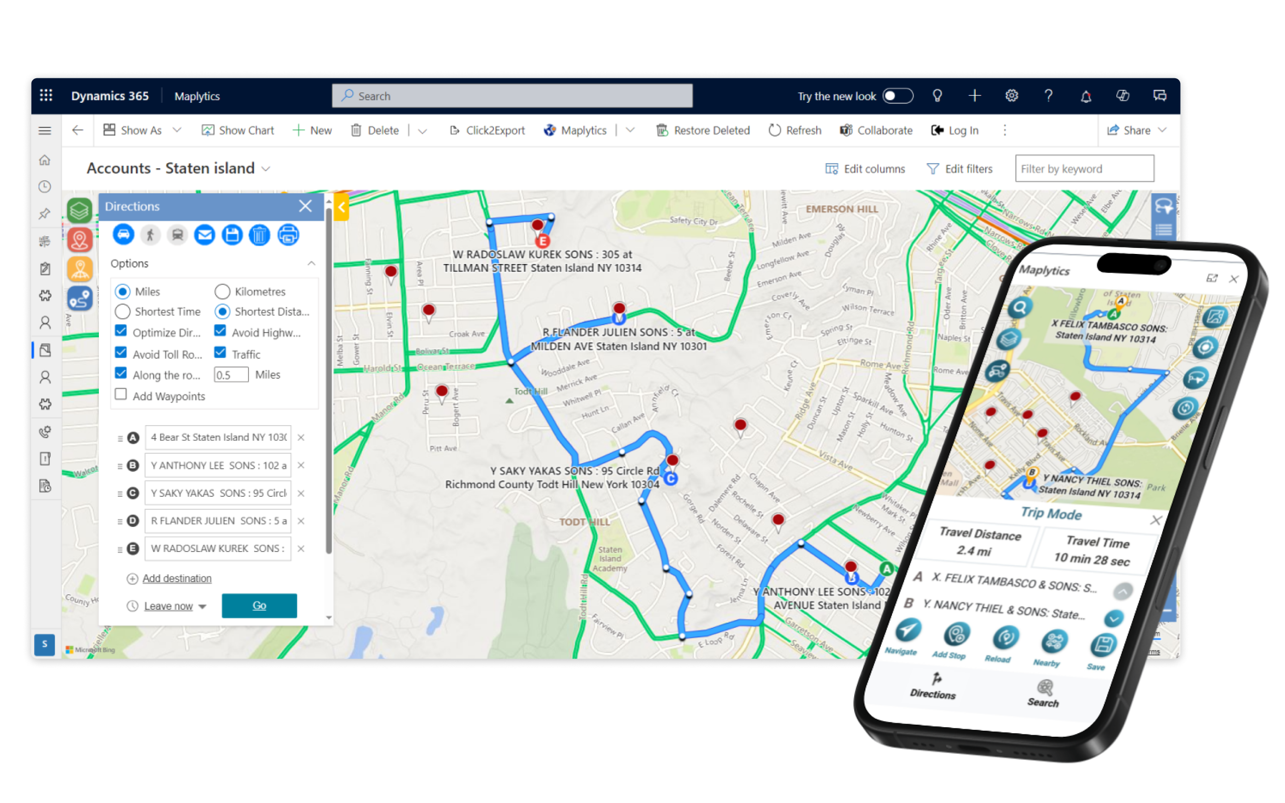
Maplytics helps sales and field teams plan the most efficient travel routes directly within Dynamics 365 CRM. Create optimized routes between multiple customer locations, reduce travel time, and manage field visits without leaving CRM.
- Optimize Every Journey: Choose the best route based on your mode of transport and avoid traffic, toll roads, or highways when needed.
- Save and Share Routes: Save optimized routes in Dynamics 365 and share them with colleagues by email or print them for easy reference.
- Improve Field Productivity: Spend less time planning travel and more time meeting customers with smarter route planning.
How to quickly find Nearby Customers and Leads in Dynamics 365 CRM?
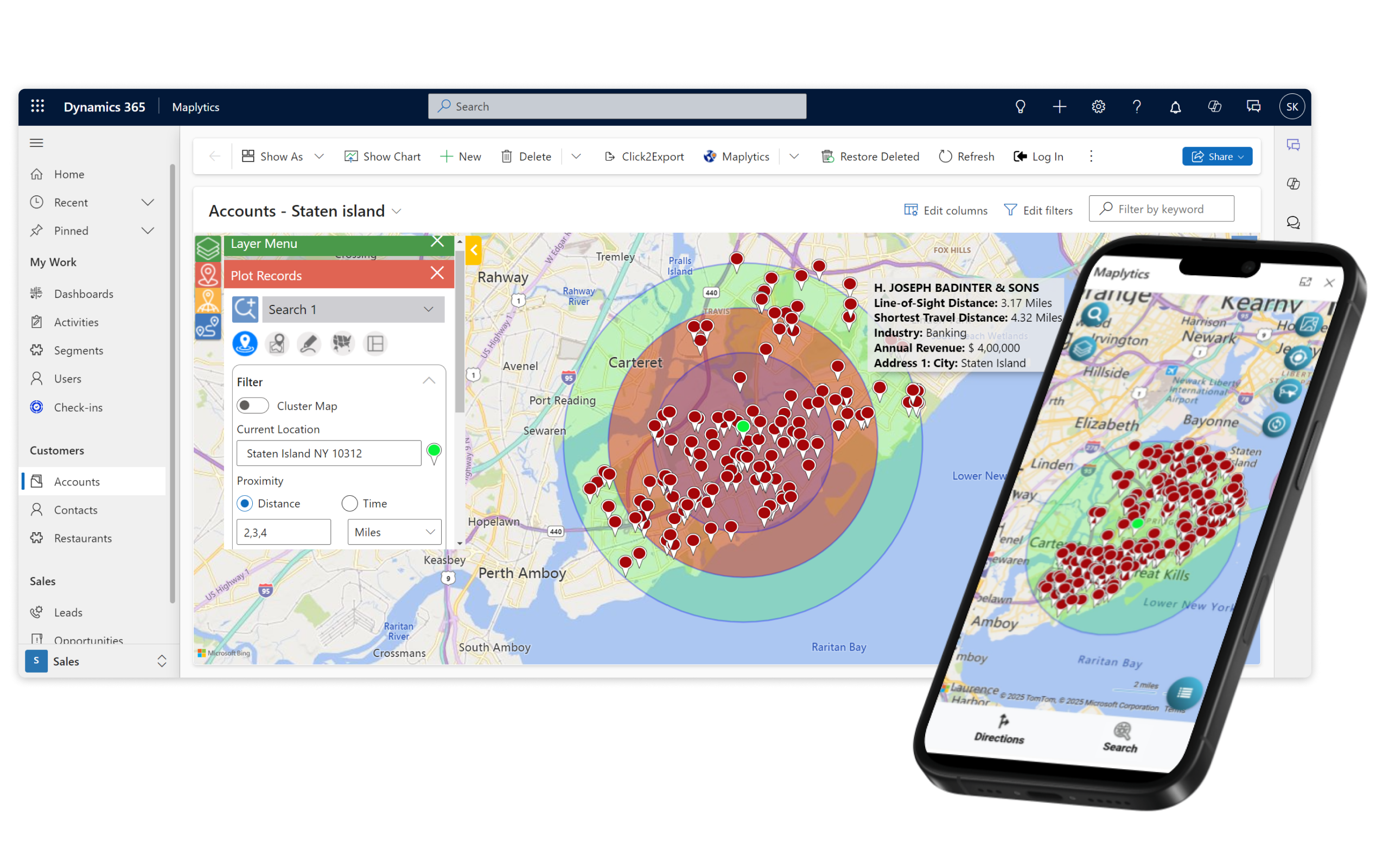
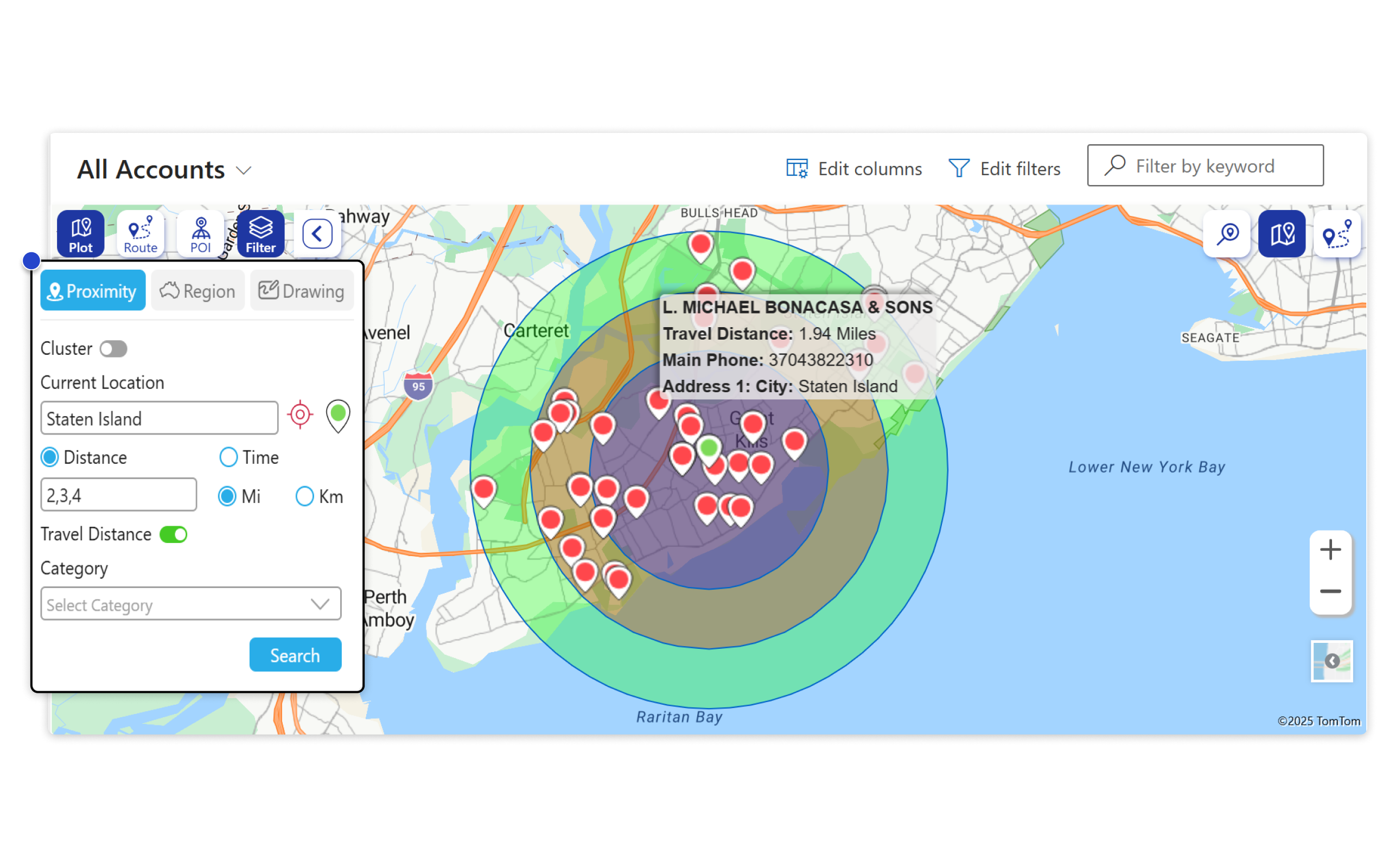
Maplytics helps users quickly find nearby customers, leads, or other Dynamics 365 CRM records using Radius Search. Search by distance or travel time to find the closest customers, leads, or CRM records and plan visits more efficiently.
- Search by Distance or Travel Time: Find nearby records within a selected radius and view the fastest or shortest route to reach them.
- Compare Multiple Search Areas: Use multiple radius rings to analyze customer distribution and identify opportunities across different locations.
- Plan Visits More Efficiently: Locate nearby prospects, customers, or service locations and prioritize visits based on proximity.
How to create and manage balanced sales territories in Dynamics 365 CRM?
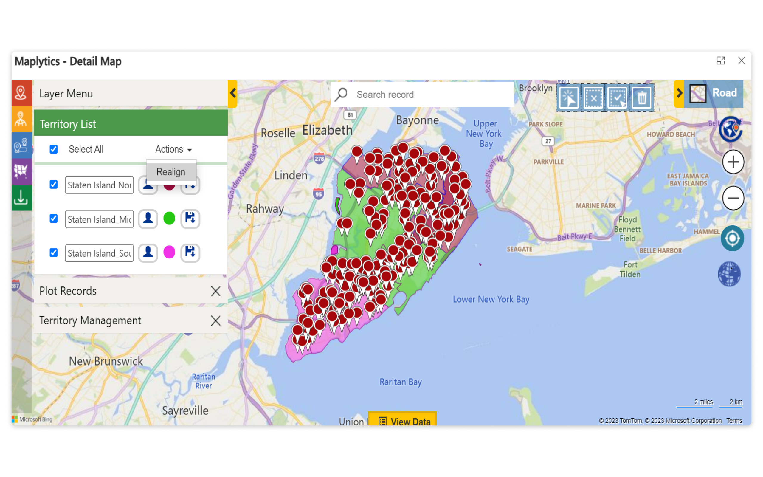
Maplytics helps sales managers create, assign, and manage territories directly on the map. Build territories using map shapes, regions, or imported Excel and shapefiles, then organize them based on your business needs.
- Create Flexible Territories: Build territories using geographic regions, numeric values, or custom filters.
- Automatically Assign Records: Assign customers and leads to the right territory based on your defined rules.
- Balance and Adjust Territories: Realign territories, auto-create new ones, and save map regions as drafts for future updates.
How to Plan and Schedule Field Visits within Dynamics 365 CRM?
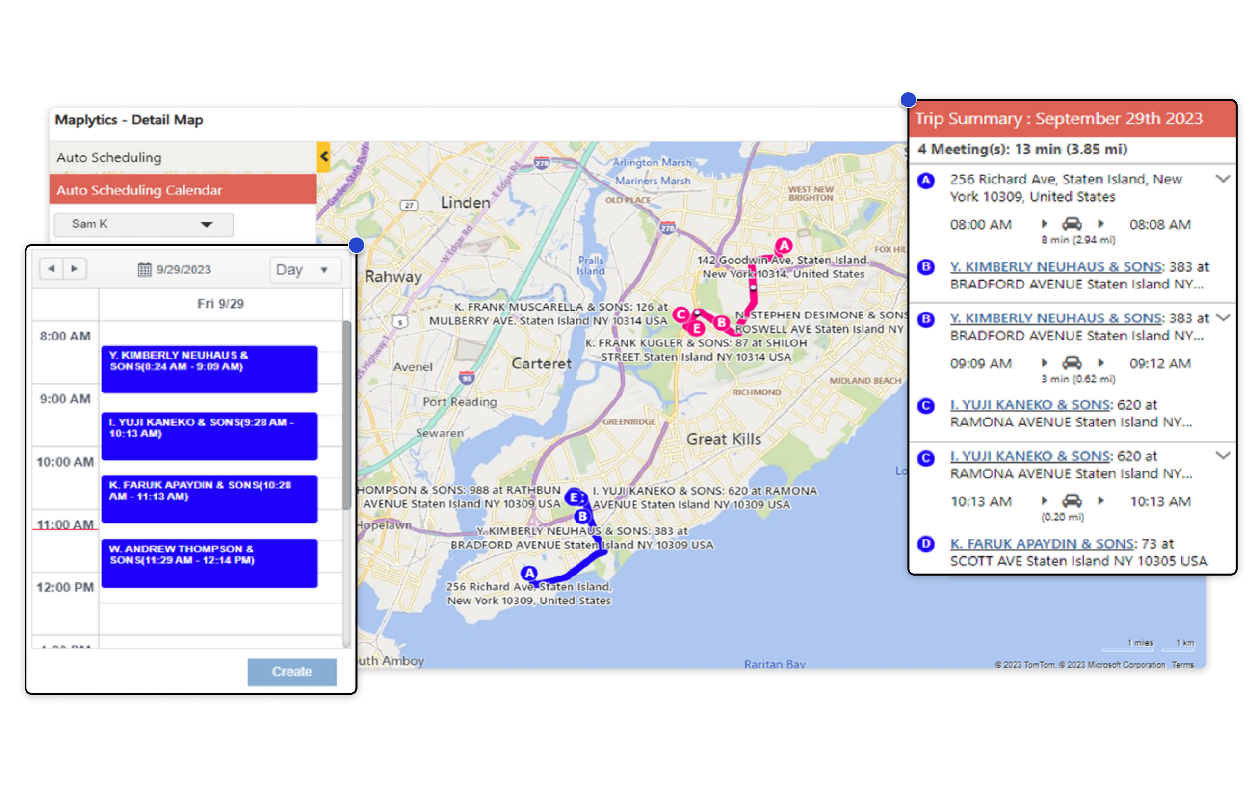
Maplytics helps managers and sales teams automatically schedule customer visits based on resource skills, availability, and client preferences. Create optimized schedules for multiple field reps, reduce travel time, and save routes and appointments directly in Dynamics 365 CRM.
- Smart Appointment Scheduling: Automatically create optimized schedules for multiple field users based on skills, availability, and customer preferences.
- Save Routes and Appointments: Generate routes, assign unique route colors, and save schedules directly in Dynamics 365 CRM.
- Track Field Visits: Check in and check out of appointments from the location to monitor completed visits.
- Reschedule with Ease: Automatically include existing meetings or reschedule appointments based on your scheduling preferences.
How can AI assist sales and field teams using Dynamics 365 maps?
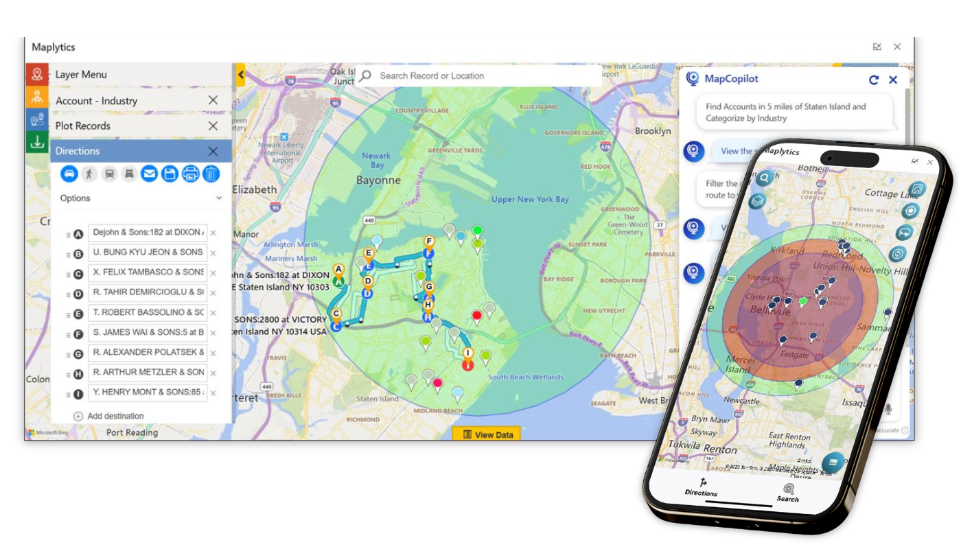
MapCopilot is the built-in AI assistant in Maplytics that helps users interact with Dynamics 365 CRM using natural language. Simply describe what you want to find or analyze, and MapCopilot maps the results instantly – no manual filtering or complex searches required.
- Search with Natural Language: Ask MapCopilot to find customers, leads, or other CRM records using simple prompts.
- Map and Analyze CRM Data: Plot records, run proximity searches, optimize multi-stop routes, and find nearby places such as hotels, restaurants, or gas stations.
- Continue the Conversation: MapCopilot remembers previous prompts, making it easy to refine searches and explore CRM data step by step.
- Work Faster with AI: Save time on everyday mapping tasks and make quicker, location-based decisions from both desktop and mobile.
How can I map Dynamics 365 CRM records using address data?
Maplytics automatically geocodes the address information stored in your Dynamics 365 CRM records, converting it into map coordinates that can be visualized on Bing Maps or Azure Maps. Once mapped, you can analyze customer locations, plan optimized routes, perform proximity searches, and make better location-based decisions.
- Automatically Geocode CRM Records: Convert customer addresses into map locations without leaving Dynamics 365.
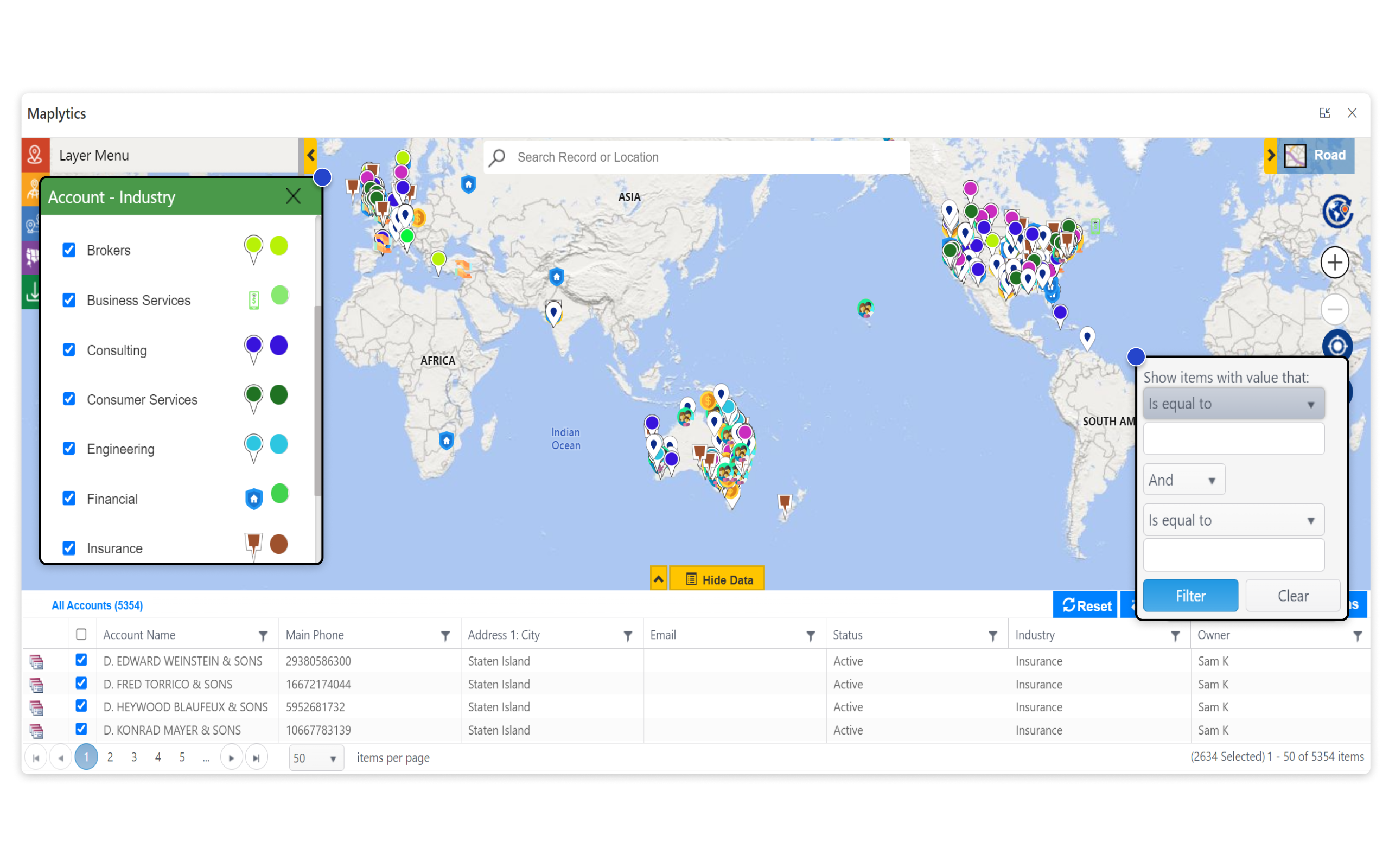
- Visualize CRM Data on Maps: Plot Accounts, Contacts, Leads, and other records on Bing Maps or Azure Maps.
- Power Location-Based Planning: Use mapped records for route optimization, territory management, proximity search, and other Maplytics features.
How can I use Azure Maps in Dynamics 365?
Maplytics List Control brings Azure Maps directly into Dynamics 365, making it easy to visualize and work with CRM records from the list view. Plot records, perform proximity searches, optimize routes, and apply filters—all without leaving Dynamics 365.
- Map Records from the List View: Plot Dynamics 365 records on Azure Maps with a single click.
- Run Location-Based Searches: Perform proximity searches, optimize routes, and filter records directly on the map.
- Works Across Microsoft Apps: Use Maplytics List Control with Dataverse, Power Pages, and Canvas Apps for a consistent mapping experience.
More Features
Truck Routing
Plot optimized truck routes on a map within Dynamics 365 using the routing solution, with details of the traveling truck, the materials carried in it, and the navigation directions dedicated to travel, mentioned.
POI Locations
Find places of interest nearby, like Coffee Shops, Gas stations, Restaurants, Airports, and a lot more by selecting the proper icons or entering relevant keywords. Pick up the nearest convenient spot for quick meetings.
Multiple Categories
Plot multiple categories for a single entity on the map within Dynamics 365 CRM as a single pushpin, where each category is taken into consideration, and the final pushpin is a juxtaposition of all three categories.
PCF Controls
Add custom controls on fields or grids within Dynamics CRM to view records on a map on the data set or the dashboards that are shipped along with the solution.
Bing Maps License
Use the Bing Maps License free of cost shipped along with the solution or enter your own Bing Maps Key.
Census Data
Plot Census Data on a map to visualize Housing units, Land & Water Area distribution, Population Demographics, and other details to make informed decisions.
Turn-By-Turn Navigation
Follow the Dynamics 365 route map with turn-by-turn navigation using Waze App, Apple Maps, or Google Maps with live traffic updates and quick re-routing in case any waypoint is rescheduled/removed.
Multiple Territories
For custom business needs, visualize records with deeper insights for multiple territories plotted with common records.
Modify Pushpins & Data Grid
Bring your icons for pushpins for a personalized view. Also, customize the proportion of the view data grid visible on the map for easier analysis.
Dataverse Support
Deploy Maplytics on Power Apps with Support for Dataverse without any compromise on quality and security with brilliant UX and UI.
Personalize Settings
Maplytics, the Dynamics 365 mapping tool offers the ability to personalize the app based on your preferences at both the user and organization levels in Dynamics CRM and therefore offers seamless mapping services.
Heat Maps
Get a better understanding of market geography to spot patterns and identify trends by using Pie charts and Column charts in Heat maps in Dynamics 365 for complex data analysis.
Plot From File
Plot From File enables users to visualize external data on maps without importing it into Dynamics 365 CRM. By uploading files in formats like .xlsx, .csv, .shp, .kml, or .geojson, users can plot and analyze geographic information directly. This functionality streamlines data analysis by allowing immediate visualization of external datasets without the need for CRM integration.
Maplytics in Canvas Apps
Maplytics seamlessly integrates with Canvas Apps, bringing powerful mapping capabilities to custom Power Apps. Users can visualize records, optimize routes, and perform locational analysis directly within their Canvas Apps, enhancing location-based decision-making. This integration ensures a smooth, interactive mapping experience tailored to unique business needs.
Multi- Address Plotting
Multi-Address Plotting in Maplytics allows users to map multiple addresses for a single record within Dynamics 365. It supports CRM’s out-of-the-box Entity Addresses, enabling users to fetch specific addresses like primary business locations while filtering out others using Fetch XML. This feature ensures precise address mapping, streamlining location-based decision-making and enhancing workflow efficiency.
Device Compatibility
Stay mobile and visualize your Dynamics CRM data on Android, iOS, and Windows, Mobiles, Tablets, etc.
Color Coded Pushpins
Define the ranges for category attributes and select the color & shape of pushpins.
Multi-Language Support
Maplytics currently supports English, German, French, Spanish, Portuguese, Turkish, Hungarian, Dutch, Polish, Arabic, and Russian languages.
Plot related records
Perform drill-down analysis of a particular record by plotting its related (child) records on the map and studying their relationships.
Marketing Lists
Create Localized Marketing Campaigns and boost conversions by building a targeted marketing list that can be approached to generate leads and sales.
Save Search Criteria
Save time by saving search criteria like data source, category, search parameters, and more as a template and plot them directly whenever necessary.
Analytical Dashboards
Get an insightful overview of Dynamics 365 data with Analytical Dashboards on a map that gives a quick summary of the data plotted on the map.
Real-Time Tracking
Managers can track Sales and Service Reps' real-time locations, history, and daily plans in Dynamics 365, with Start & End Times shown in the tracked location's time zone for accuracy.
Territory Assignment Rule
Maplytics Admins and Managers can create simple/advanced rules based on which territories will be assigned to the records as per the required conditions.
Land Area Mapping
Define the area of land as agricultural, residential, or commercial properties and visualize the same on the map.
MapPoint Alternative
Maplytics is a preferred upgraded solution and an ideal replacement for Microsoft MapPoint in Dynamics 365 CRM
Maplytics API
Show Maplytics search results outside Dynamics 365 using API for Maplytics.
A complete guide to enhance Dynamics 365 Field Service with Integrated Maps!
testimonials
What Our Customers Are Saying?
The Best PowerMap Replacement: Maplytics with Built-In Bing and Azure Maps License
PowerMap users are facing Bing Maps licensing troubles, and many organizations are discovering that their mapping functionality is restricted…
Meet MapCopilot — Your AI-Powered Geo-Mapping Companion for Dynamics 365
In the modern digital landscape, data visualization and spatial intelligence are central to effective decision-making. Maps no longer just display locations…
A Quick Guide: How AI Simplifies Field Service Appointment Scheduling in Dynamics 365 CRM
Field service teams across the U.S. and North America face a common challenge – scheduling appointments efficiently while keeping customers satisfied…
Frequently Asked Questions
Integrating maps with Dynamics 365 CRM brings your data to life by adding a geographical dimension to customer insights. 80% of data has a locational component to it, and this helps users visualize records spatially, plan balanced territories smartly, optimize routes for the economical travels of field reps, and schedule appointments efficiently. This not only enhances productivity but also supports data-driven decision-making. A Microsoft-certified, geo-analytical tool like Maplytics subtly empowers these capabilities right within Dynamics 365, Dataverse, Power Pages, and Power Apps like Canvas App, enabling smarter operations and deeper customer engagement.
No. Maplytics is a managed solution that runs natively inside your Dynamics 365 environment. It doesn’t host or store your CRM data on any separate cloud service. Only the address fields needed for a specific map action (like geocoding) are sent to Bing Maps to retrieve coordinates. The rest of your CRM data never leaves your Dynamics 365 instance or gets copied anywhere.
Maplytics is 100% native to Dynamics 365, Power Platform, Dataverse, and Power Apps. It’s installed as a managed solution directly inside your CRM environment rather than connecting as an external, separately hosted application. This means no separate login, no data syncing between systems, and no additional integration layer to maintain.
Maplytics supports Dynamics 365 Online, on-premises, and partner-hosted deployments.
Maplytics is built by Inogic, a Microsoft Gold ISV Partner with over 15 productivity apps for Dynamics 365 and the Power Platform, spanning geospatial, document management, productivity, and integration categories. Maplytics is Inogic’s flagship product and one of the first apps to receive a “Certified Software” badge on Microsoft Marketplace.
Maplytics holds a 5-star rating on Microsoft AppSource, making it one of the highest-rated geo-analytical apps available for Dynamics 365.
Maplytics supports clustering of up to 25,000 records on a single map view, allowing large datasets to be visualized without performance issues, useful for organizations plotting nationwide or global account bases.
Maplytics is installed as a managed solution, either downloaded from Microsoft Marketplace (formerly AppSource) or imported from www.maplytics.com. After import, you activate it under Maplytics App → Settings → License Registration, where a free 15-day trial license is generated automatically. No separate Map key setup is required to get started.
Yes. Inogic maintains backward compatibility across Maplytics updates, so upgrading to a newer version doesn’t break or require reconfiguration of existing territories, saved routes, schedules, or settings.
Yes. A route planned on the Maplytics desktop view can be viewed directly on your mobile device, where it opens with turn-by-turn voice directions on Google, Apple Maps, or Waze Apps, useful for field reps who plan their day at a desk but navigate from their phone.
Yes. With Maplytics’ Power Pages integration, Dynamics 365 records can be visualized on external-facing websites, including for visitors who aren’t registered Power Pages users, extending location intelligence beyond internal CRM users to customer- or partner-facing portals.
Yes, via Maplytics’ “Plot by Template” capability, users can save a specific combination of search criteria, data source, and category filters as a reusable template, then apply it instantly in future sessions instead of reconfiguring filters from scratch each time.
Yes. Inogic runs a Partner Program for Microsoft Dynamics CRM consulting firms and resellers interested in reselling or implementing Maplytics for their clients. Interested firms can apply by contacting crm@inogic.com.
Pricing details vary by deployment size and aren’t fixed at a single number. Inogic provides a quote based on user count and requirements (see “Get a Quote” on the site).
Put your Dynamics 365 CRM data on the map and turn location into your biggest sales advantage!