
An average savings of 12 minutes per appointment travel, or approximately 12 hours per day, resulting in an operational savings of $5,000 per month! Yes, these were the amazing stats recently reported by ReEmployAbility, a B2B Service Industry Company that provides simple, fast, safe return-to-work solutions to help control the rising costs of workers’ compensation and non-occupational disability while positively influencing the lives of injured workers nationwide.
In today’s fast-paced world and globally expanding businesses, Microsoft Dynamics 365 CRM users often feel restricted due to the lack of geo-location-based intelligence while analyzing their CRM data. This often results in skewed decision-making, sub-optimal operating efficiencies, lack of real-time visibility into daily operations, inadequate control over travel expenses, and loss of productivity.
In combat against the situation, Inogic has created an all-inclusive, comprehensive geo-mapping app that empowers business decision-makers to harness the power of geo-analytics by visualizing CRM data on the Map, named Maplytics or Map-Analytics. Let us have a detailed look.
What is Maplytics?
Maplytics™ is a comprehensive and powerful Geospatial and Analytical Mapping solution for Microsoft Dynamics 365 CRM users. It is designed to enable Microsoft Dynamics 365 CRM users to leverage location intelligence to plot, plan, analyze, and take action on their CRM data. It empowers users across industry verticals with Geographical Data Visualization, Optimized Routing, Appointment Planning, Proximity Search, Heat Maps, and Territory Management to drive better sales, improve business processes and engage customers at the right time.
What is the value/benefit?
The key benefits of integrating Microsoft Dynamics 365 CRM with Bing Maps using Maplytics are:
- Better understanding, analysis, and improved decision-making in real-time
- Strong relationships and improved quality of customer engagement and discussions
- Reduced fuel consumption and shortened time of travel
- Effective targeting in new markets
- Strong and good client relationships
- Upscaled Business Productivity
Partner Solution Showcase – Maps for Microsoft Dynamics 365 CRM & Dataverse
As an innovative products-producing hub within Microsoft Dynamics 365 CRM, Team Inogic was thrilled to present a live session on Maplytics to the wonderful interactive attendees at the Community Summit, NA, 2022.
The unique features of Maplytics, those aid organizations in generating leads on the go, strategizing targeted marketing plans, planning and forecasting sales updates, visualizing CRM data on maps, reducing mileage costs, having a work-life balance, and so much more were discussed at length.
We stressed the growing significance and the necessity of Location Intelligence, geo-analytics, etc. for Businesses across industries, discussed the unfathomable applications & possibilities of Maplytics in various industries, and walked through the amazing 15 Microsoft Preferred Productivity Apps of Inogic.
A glimpse of the same can be viewed on our YouTube channel-
What are the popular features of Maplytics?
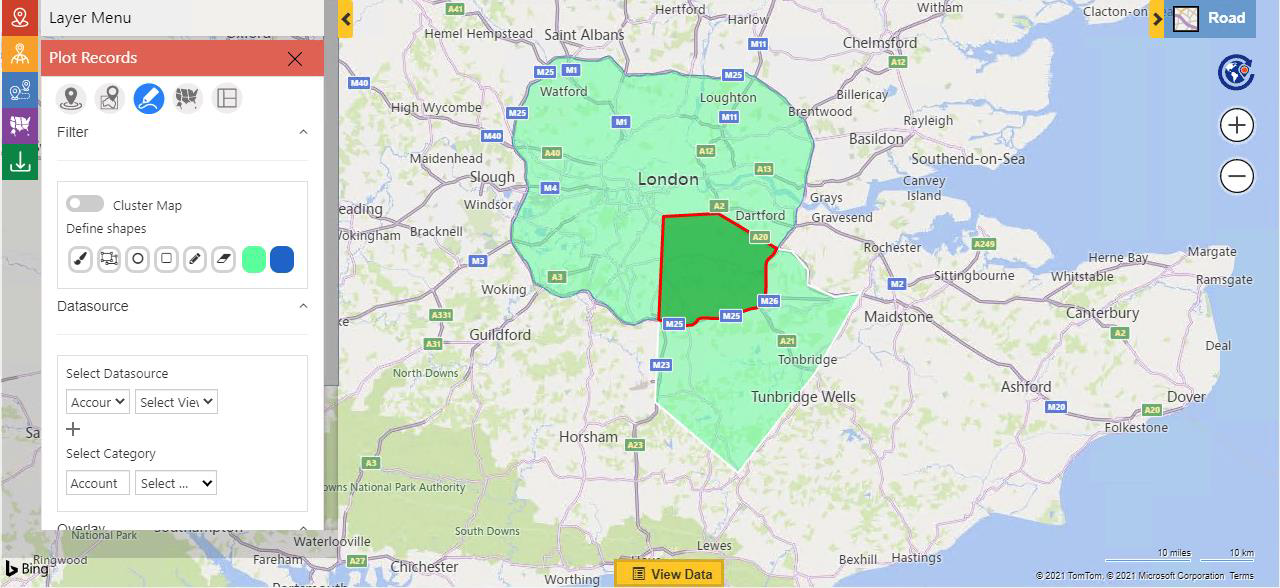
Plot Records
Microsoft Dynamics 365 CRM records can be plotted over the Map with respect to their location, region, territory, etc. The whole-sellers of the Beverage giant can be displayed easily in this manner. Plotted records can be used for further business decisions
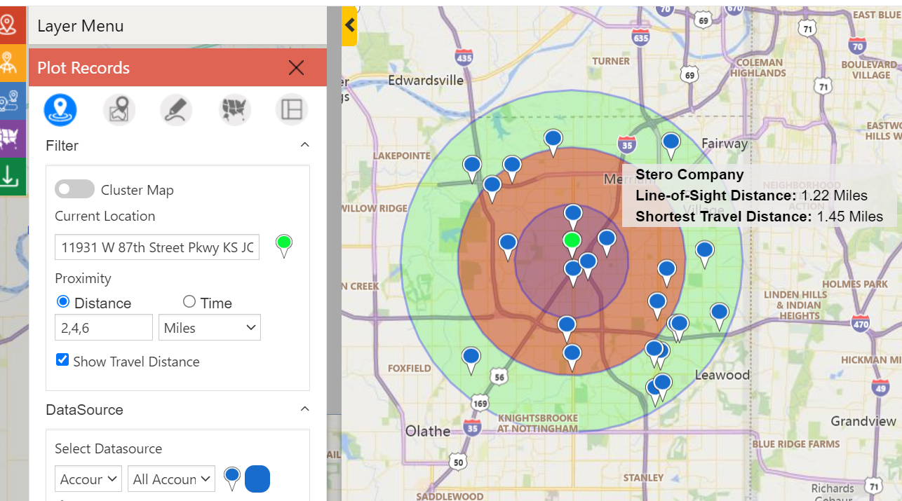
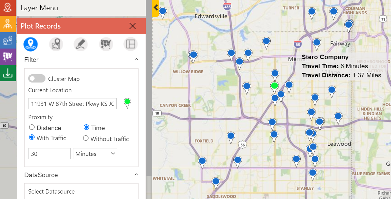
Radius/ Proximity Search
If the current location of an on-field rep is provided and if he intends to find a retailer within a radius of 5 miles or kilometers around him, he could provide his desired number and the proximity of existing/potential retailers within that circle could be searched using the maps within Microsoft Dynamics 365 CRM. He could even plot them based on the number of hours/ minutes required to reach them from his current location. The rep could plot multiple circumferences by providing up to 3 radii options.
Along the Route
The records/ Clients that fall in a defined proximity and along the plotted route can be searched and added on to the existing route. If a rep is on his plotted route and has some spare time to accommodate an additional Client Meet, he could search for an available Client on his route and meet him.
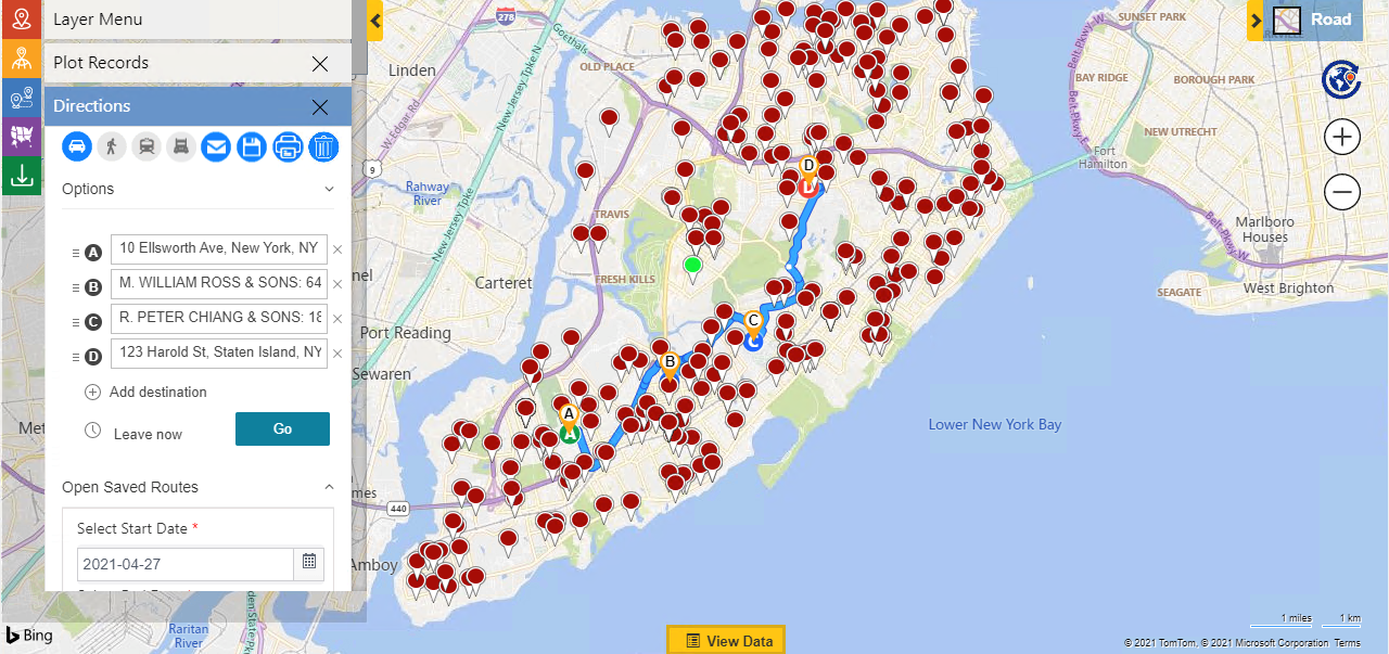
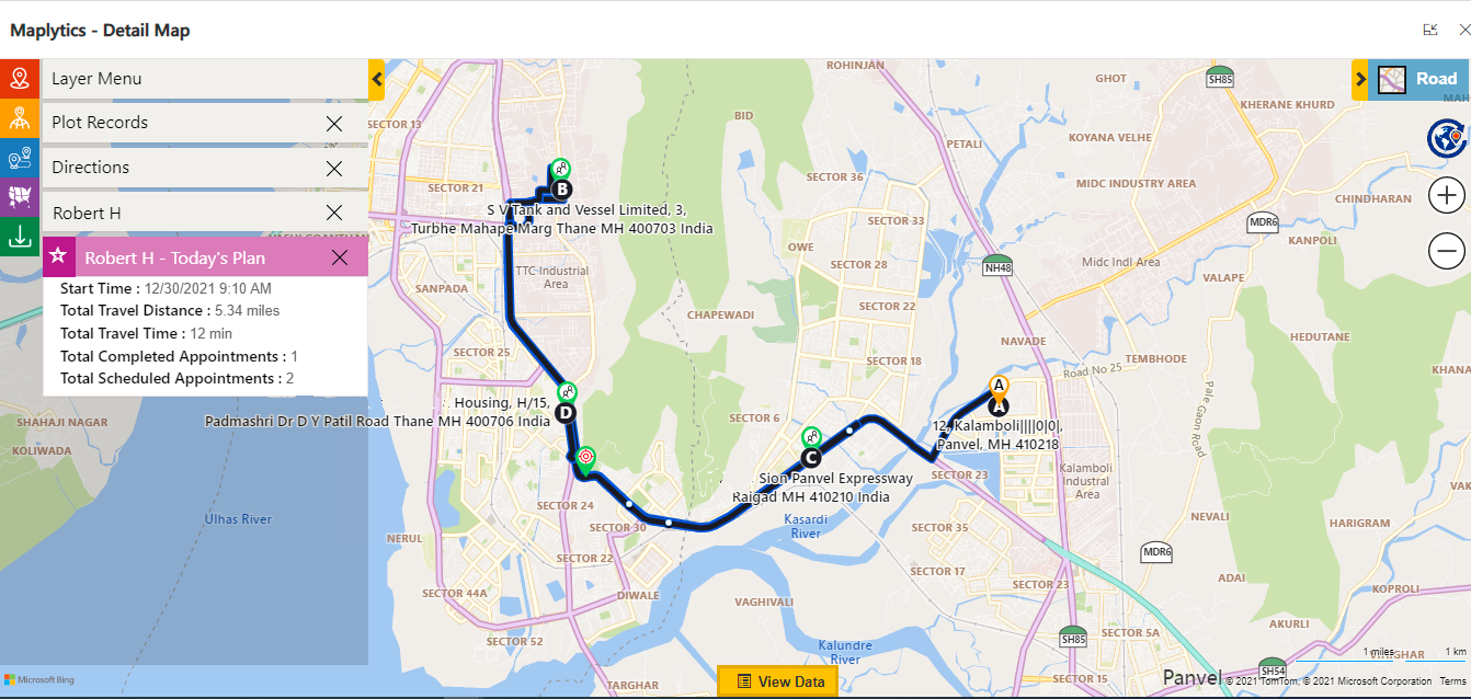
Optimized Routing
If a sales rep has been allotted 4 restaurants to pay a visit to in a day, this feature helps in plotting an optimized travel route that is shortest in terms of the distance he’ll have to travel and the time taken to travel. It also helps in finding possible traffic-free and toll-free routes.
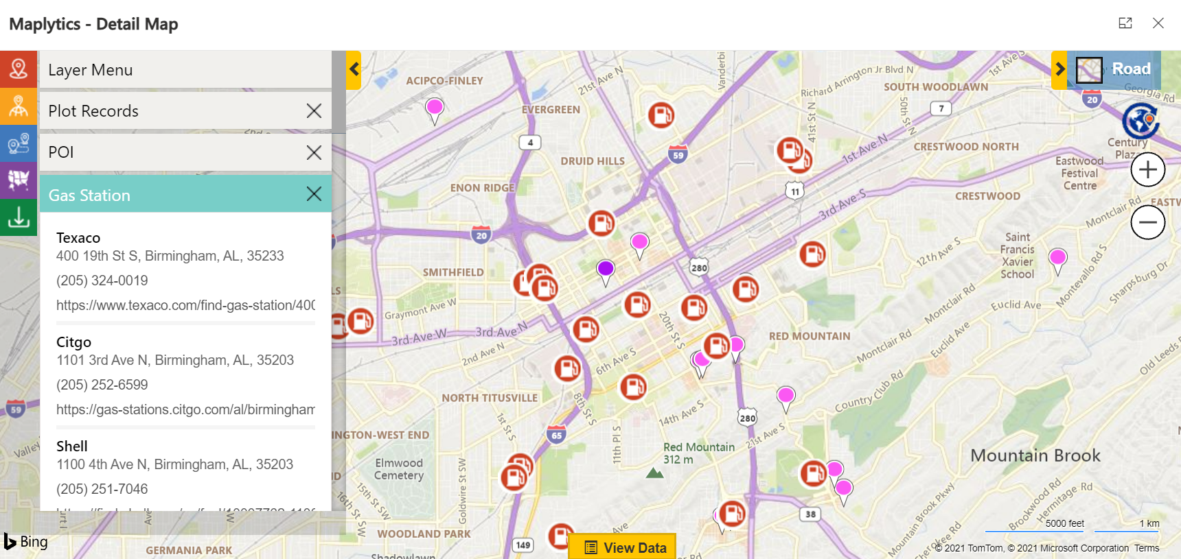
POI (Point Of Interest) Locations- Places such as Cafes, Hotels, Airports, etc. along a route or near a Client can be searched specifying a particular location of interest. The rep could conduct his meetings at such places, have his food, refill his car, etc.
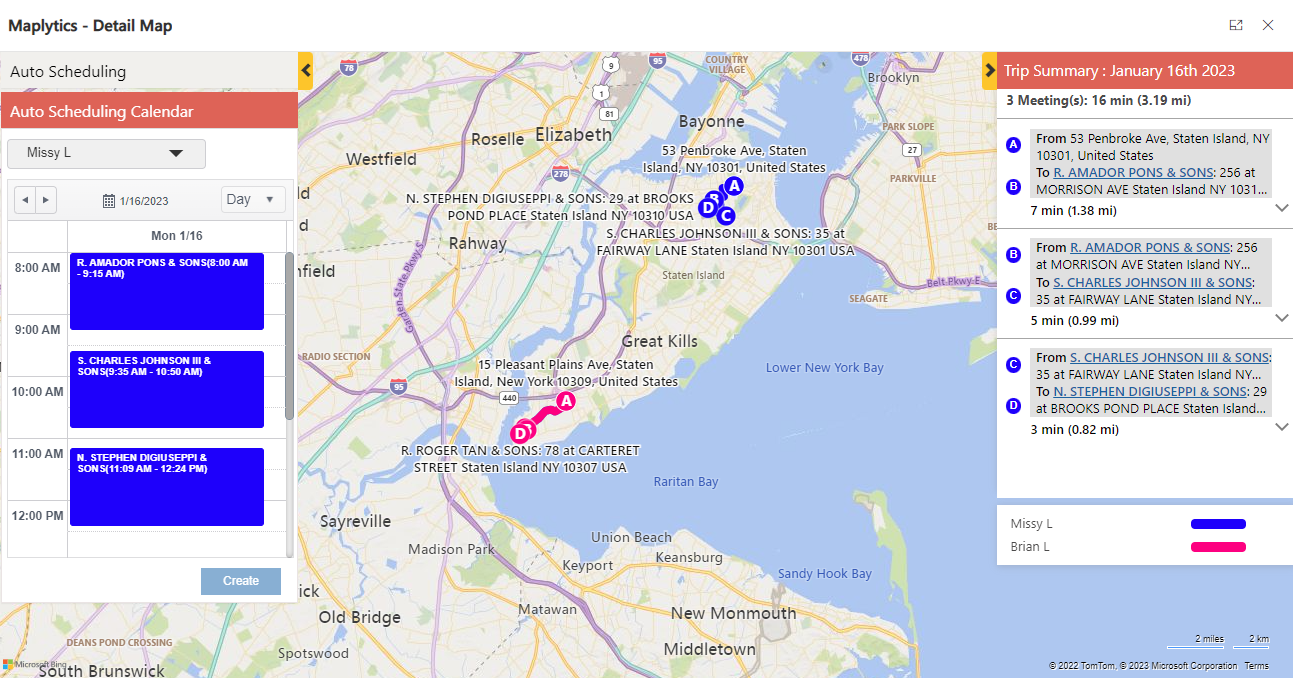
Auto Scheduling
Client appointments for a day/s can be auto-scheduled using maps within Microsoft Dynamics 365 CRM. The schedules can be updated in case of ad-hoc changes. This way both the reps and the managers are pre-planned, organized, and ready for the appointments.
Real-Time Tracking
The resources/ field reps can be tracked when in real-time. Their routes can be monitored and saved for future use. This prevents waste of time, unhandled emergencies, and untapped travel.
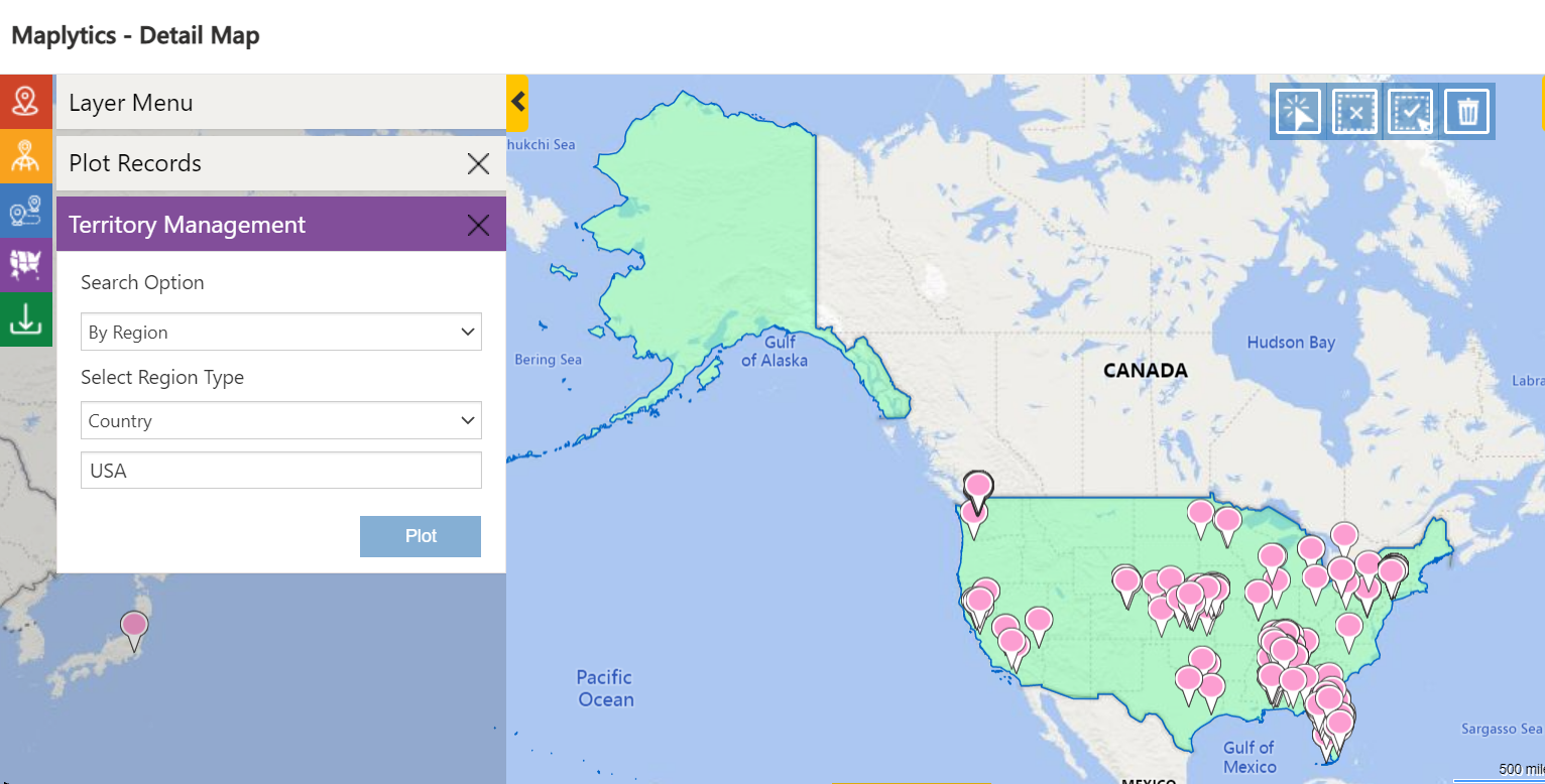
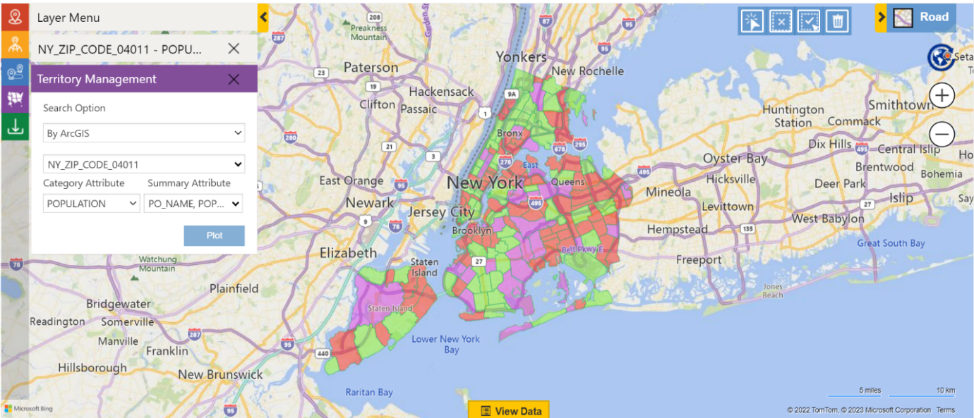
Territory Management
Territory Management, a powerful feature, is used to sort and plot data based on Territories. The ease of the feature aids multiple users in creating multiple territories based on the record required, categories selected, physical shapes drawn, altered, or edited existing marked territories, and so on. One can create, draft, align and manage territories as per one’s business needs. Auto creation of territories is one of the upgraded benefits.
An organization can mark multiple territories to plot and manage multi-level territories popularly termed hierarchical territories. Thus, in case there are any child territories created and associated with the selected territories, those too will get plotted on the map along with the selected territories. If Austin Texas has a child territory of Wimberley, it too shall be plotted when Austin shall be selected.
Detail Map
All the desired displays are visible because of Detail Maps. The Detail Map is used to plot data on a Road Map or in an Ariel View. In a Detail Map, the Beverage Company’s sales team can plot the Records of the Clients based on the selected Data Source, Category, and Proximity from the Current Location or Overlay.
Heat Map
Heat Map is a visual data analytics tool that displays actionable insights through a visual representation. The user can visualize the data in the form of colored boundaries, pie charts, or column charts.

Land Area Mapping
Users can assign specific land regions to the records. These regions can then be visualized on the map to understand the coverage of the area for each of the records.
Mobility across Devices
Maplytics can be accessed from Microsoft Dynamics 365 App for Phones and Tablets using a dashboard for the Detail Map. The current GPS Location can be picked up for advanced auto-scheduling. Maplytics is compatible with desktops, laptops, mobile, tablets, windows, iOS, and Android.
Multiple language support
Maplytics is a multi-language solution. It is currently available in eleven different languages namely German, French, Spanish, Portuguese, Turkish, Hungarian, Dutch, Arabic, Polish, and Russian along with English as the default language.
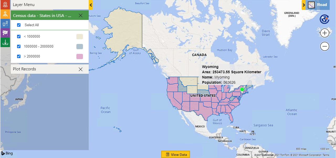
Census data visualization
The Census data is visualized on the Map to help the users take strategic decisions for an entire country or a region keeping their business goals and plans in mind.
Overlay
The users can mark and view the Microsoft Dynamics 365 CRM records along with the shape/excel files/ ArcGIS and the existing territories plotted on the Map. An overlay record can also be converted into a different territory.
Shape Operations
The users can perform Binary Operations on the shapes drawn on the Maps. Through these operations, the overlying shapes could be eliminated, intersecting shapes could be highlighted, and overlapped shapes could be merged as one, and so on.
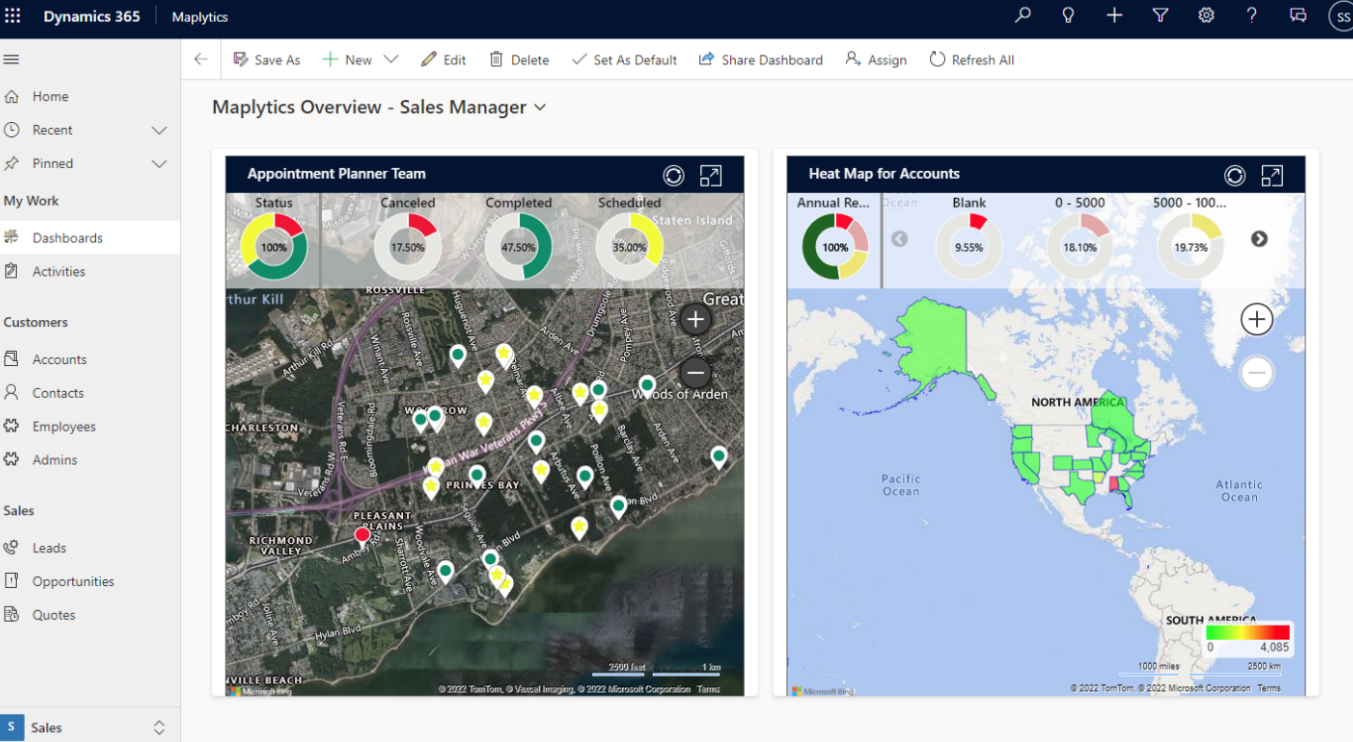
Maplytics Dashboard
With the help of Dashboards, one can visualize and analyze Dynamics 365 CRM data and insights. The Dashboard view for Maplytics can also be customized.
To get more acquainted with Maplytics and experience it first-hand, one can write to them at crm@inogic.com. To explore the product in depth, with a free trial of 15 days, or a personalized demo within Microsoft Dynamics 365 CRM / Dataverse get in touch with the Team.
For applied knowledge, do visit the Website or Microsoft AppSource. For a quick query resolution, one can hop on to the detailed Blogs, Client Testimonials, Success Stories, and Video Library.
The other offerings of Inogic boast of-
- Gamifics365– the latest Gamification app for Dynamics 365 CRM motivates, engages, and increases user adoption
- Click2Clone, Alerts4Dynamics, Click2Export, Click2Undo, Lead Assignment & Distribution Automation, and User Adoption Monitor aid in overall productivity enhancement
- Attach2Dynamics and SharePoint Security Sync help in streamlining Document Management and so on
Until then,
Happy Mapping!