
In the modern digital landscape, data visualization and spatial intelligence are central to effective decision-making. Maps no longer just display locations, but
- interpret business movement,
- drive smarter workflows, and
- enable teams to act faster
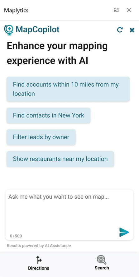
Introducing MapCopilot, the latest innovation from the glorious Maplytics suite, designed for users of Microsoft Dynamics 365 and Dataverse who want to enjoy intelligent geo-mapping without the manual setup.
With MapCopilot, users no longer need to work with complex filters, remember specific map configurations, or toggle between tools. Instead, they can type or speak natural-language queries, such as:
“Show all active customers within 10 miles of downtown Chicago.”
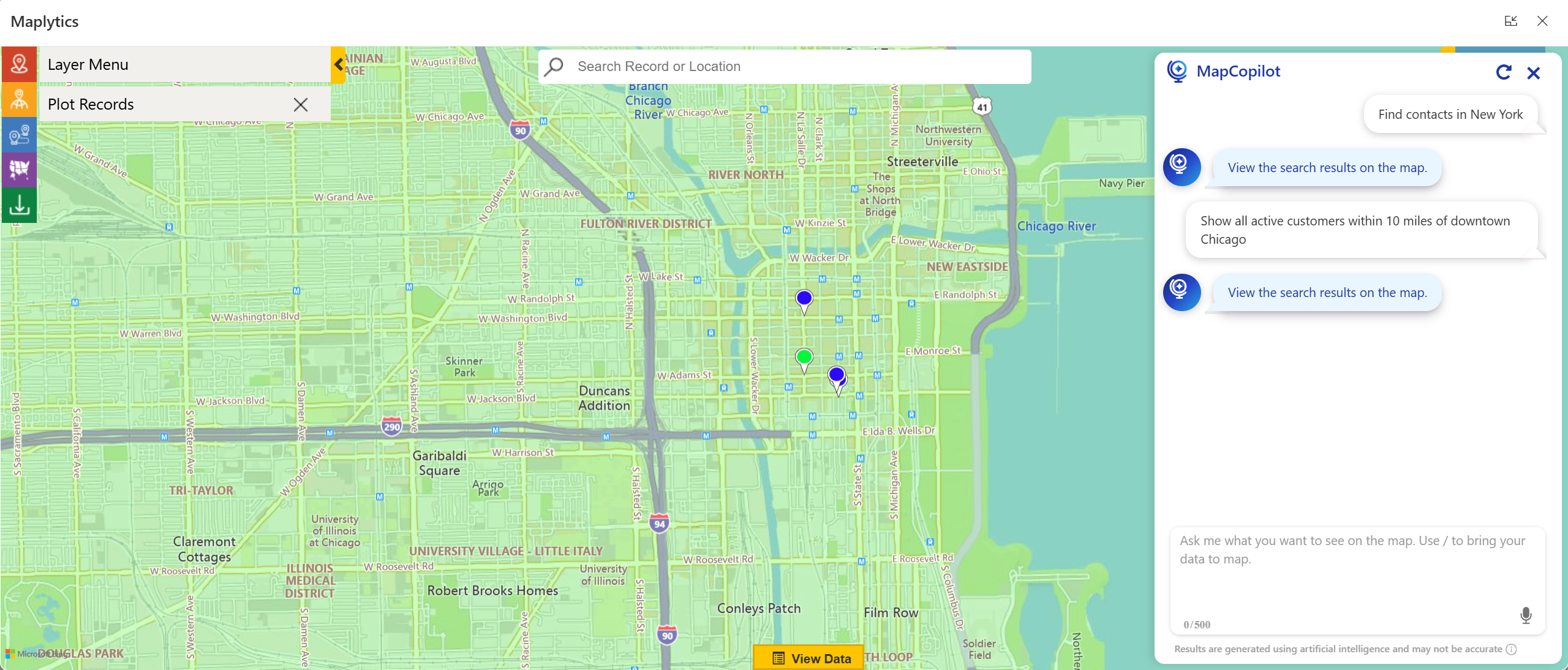
Within seconds, MapCopilot interprets the prompt, applies the right filters, and displays a fully interactive map or optimized route, all within Dynamics 365.
Whether it’s plotting locations, performing proximity analysis, or designing efficient travel routes, MapCopilot transforms spatial data into actionable intelligence, making CRM navigation simpler, faster, and conversational.
Why MapCopilot Matters?
For most CRM users, performing spatial tasks, such as identifying nearby clients, analyzing data classifications, or optimizing routes, can involve multiple steps and configurations. Even with the powerful capabilities of Maplytics, some users prefer a more intuitive, quick, “ask-and-act” experience.
That’s where MapCopilot steps in. It eliminates manual input, reducing the effort to a single, human-like interaction.
Here’s how it transforms the experience:
- Fewer clicks, faster output: Ask “Find open opportunities within 15 km of my location” and get results instantly plotted.
- AI-powered understanding: Natural-language queries are converted into accurate mapping instructions without technical know-how.
- Integrated within Dynamics 365: No third-party navigation or switching of apps is required. MapCopilot works natively inside your CRM.
As a result, teams spend less time configuring and more time analyzing, planning, and executing.
Key Capabilities of MapCopilot
- Conversational Mapping via Natural Language
With MapCopilot, maps become conversational. There’s no need to remember commands, syntax, or settings. You can simply type or speak what you need, and the AI interprets your intent.
Example commands:
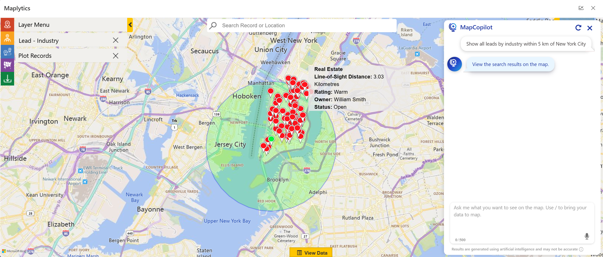
- “Show all leads by industry within 5 km of New York City.”
- “Plan an optimized route for these five accounts.”
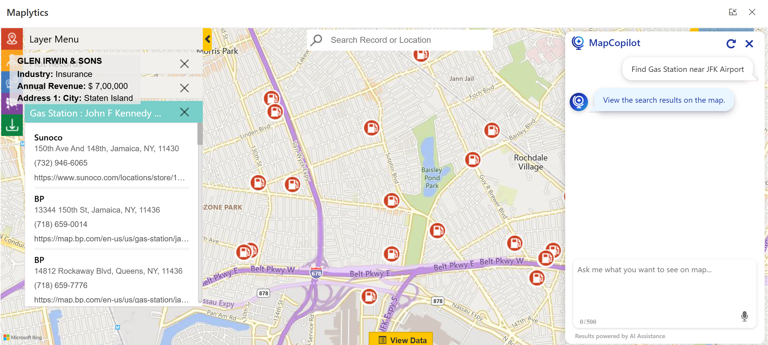
- “Find gas stations near ABC Corporation.”
This conversational design ensures every team member, regardless of technical background, can instantly gain spatial insight without relying on a GIS expert or admin.
Forget manual setup for proximity analysis. You can now ask questions like:
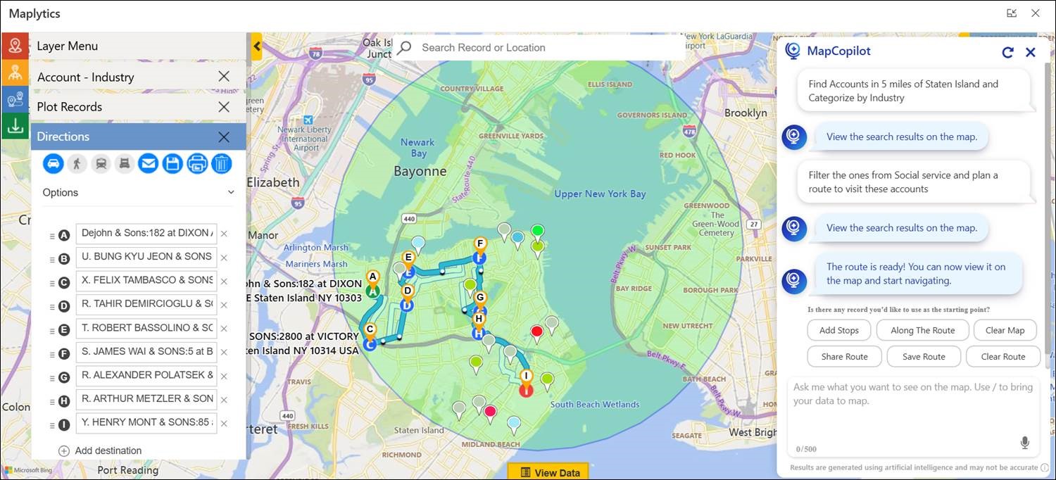
“Show accounts within 5 miles of Nancy Thiel & Sons.”
MapCopilot automatically identifies the location, calculates distance, and displays relevant records complete with radius visualization and travel time estimates.
This capability is especially valuable for sales and service teams who frequently look for nearby leads, prospects, or assets to maximize daily coverage.
Efficient travel planning is at the heart of field operations. MapCopilot makes this effortless.
Simply specify your destinations, or just ask, and the assistant builds the shortest, most efficient route, considering real-world factors like travel distance, stop sequence, and accessibility.
Resulting benefits include:
- Reduced travel time and fuel expenses
- Increased customer visits per day
- Improved productivity for every field rep
- Points of Interest (POI) Location
MapCopilot goes beyond CRM data. It helps users identify Points of Interest (POI) Locations like airports, restaurants, repair shops, or gas stations around any given area, enhancing travel convenience and opportunity identification.
- Work from Anywhere, Anytime
With distributed teams becoming the norm, MapCopilot ensures that location intelligence stays with you on the move.
Its native integration with Microsoft Dynamics 365 allows users to access mapping data, optimized routes, and analytical insights from any device, anytime.
- Context-Aware Conversations
Unlike standard assistants that reset after each query, MapCopilot maintains context awareness.
Start with:
“Plot all opportunities in California.”
Then continue with:
“Now show only those with revenue greater than $10,000.”
MapCopilot remembers your previous query, applies filters dynamically, and refines the visualization, ensuring a smooth, conversational workflow.
Technical Framework and Integration
MapCopilot is built on the Maplytics framework, powered by Azure OpenAI and tightly integrated with Microsoft Dynamics 365 and Dataverse.
Key integration highlights:
- Embedded directly inside the Maplytics interface in Dynamics 365.
- No need for third-party apps or extensions.
- Fully compatible with web, tablet, and mobile experiences.
- Optimized for fast rendering using Dynamics 365 map panels.
From installation to execution, the setup process is streamlined and ready to use. Once Maplytics is deployed, MapCopilot becomes immediately accessible to all licensed users.
Real-World Application Scenarios
Field Sales Optimization
A regional sales manager can quickly ask:
“Show all open service leads within 50 kilometers of our warehouse.”
“Now optimize the route for visiting them.”
MapCopilot instantly visualizes the results, color-codes them by priority, and generates the most efficient travel path.
This eliminates manual scheduling and lets teams focus on closing deals, not plotting maps.
Results organizations have seen:
- Up to 20% reduction in transportation costs
- 30% shorter travel routes
- 40% faster decision-making through map visualizations
Customer Service & Field Support
Service dispatchers can instantly locate nearby technicians or customer sites by asking:
“Find available engineers within 10 miles of the reported service location.”
MapCopilot identifies suitable resources and even helps auto-schedule the task through Maplytics’ routing and scheduling modules.
Marketing & Campaign Targeting
Marketers can use MapCopilot to locate clusters of leads or customers within a defined region:
“Show contacts within 20 miles of Boston categorized by campaign type.”
These insights help tailor campaigns to regional audiences, improving ROI and engagement.
Enterprise Benefits of MapCopilot
By making location intelligence conversational, MapCopilot empowers every employee, from sales and marketing to logistics and support, to make smarter, location-driven decisions without any friction.
Why MapCopilot is a Game-Changer
- Brings AI to Mapping – Makes spatial queries intelligent, quick, and contextual.
- Democratizes Data Access – Anyone, regardless of tech skill, can extract location insights.
- Simplifies CRM Workflows – Reduces dependency on admins for map configuration.
- Enhances Field Efficiency – Optimizes travel and service operations seamlessly.
- Adapts to Your Business – Supports varied industries and user roles out of the box.
Getting Started with MapCopilot
MapCopilot is available as part of the Maplytics suite for Dynamics 365 and Dataverse.
You can get started in three easy steps:
- Install or update Maplytics from Microsoft AppSource.
- Access the MapCopilot feature within your Maplytics interface.
- Start typing or speaking your mapping queries directly.
You’ll instantly experience the ease of AI-powered navigation inside your CRM.
Frequently Asked Questions (FAQs)
- Do I need technical training to use MapCopilot?
No. MapCopilot is designed for ease of use. If you can type or speak your request, you can use it, no GIS or CRM admin experience required. - Is MapCopilot a separate application?
No. It’s fully integrated within Maplytics, which runs inside Dynamics 365 and Dataverse environments. - Can it handle voice input?
Yes, users can either type or use voice commands for queries. - How does it differ from standard Maplytics features?
Traditional Maplytics workflows are menu-based, while MapCopilot uses AI-driven natural language to interpret user intent, reducing time and complexity. - Does MapCopilot support route optimization and proximity search?
Absolutely. These are built-in capabilities, powered by robust routing algorithms. - Is my data secure?
Yes. MapCopilot operates entirely within Dynamics 365 and adheres to Microsoft’s security and compliance frameworks.
Experience MapCopilot in Action
If you’re ready to make your CRM mapping effortless and intelligent, it’s time to try MapCopilot.
Start a 15-day free trial or request a personalized demo tailored to your business needs.
Write to crm@inogic.com to schedule your session.
Visit the Maplytics Website or explore it on Microsoft AppSource.
For more insights, browse our blogs, case studies, and success stories.
With MapCopilot, mapping isn’t just visual, it’s conversational, smart, and built for the future of AI-powered CRM. For applied knowledge, you can hop onto the detailed Blogs, Client Testimonials, Success Stories, Industry Applications, and Video Library for a quick query resolution. Technical docs for the working of Maplytics are also available for reference.
Kindly leave us a review or write about your experience on AppSource or the G2 Website.